MAPS
Printable pdf map
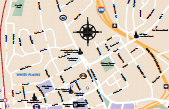
White Plains
Early in the 20th century, White Plains’ downtown area developed into a dominant suburban shopping district and featured branch stores of many famous New York-based department and specialty stores. Some of these retail locations were the first large scale suburban stores built in the United States, and ushered in the eventual post-World War II building boom.
Printable pdf map
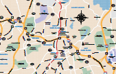
White Plains and surounding area
The City of White Plains is the county seat of Westchester County, New York, United States. It is located in south-central Westchester, about 4 miles east of the Hudson River and 2.5 miles northwest of Long Island Sound. It is bordered to the north by the town of North Castle, to the north and east by the town/village of Harrison, to the south by the town/village of Scarsdale and to the west by the town of Greenburgh.
Printable pdf map
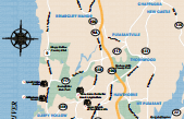
Historical Mansion Tour
Historic Hudson Valley is a museum of historic sites, buildings, landscapes, and collections. A not-for-profit educational organization, it owns, restores, preserves, interprets, and promotes historic landmarks of national significance within the Hudson Valley for the benefit and enjoyment of the public. www.hudsonvalley.org